
Defined Area Projects: Location Certainty Drives Business Impact When There Is No Alignment
Data center construction is one of the fastest-growing segments in U.S. infrastructure right now. Grand View Research estimates the U.S. data center market will exceed $276 billion by 2033, growing at roughly 10% annually. Yet, Goldman Sachs reports only about 72% of data centers scheduled for activation within the following four quarters came online on time due to labor shortages and supply chain issues. These aren't small builds: a single hyperscale campus can span millions of square feet and require years of phased construction by dozens of prime and specialty contractors simultaneously.
Projects like these, along with solar farms, mining sites, large parking facilities, and industrial campuses, share a common problem: the crews building them have no reliable way to know exactly where they are, document what they've done, or prove work happened at a specific location. They're working off paper plans, text messages, and phone camera galleries. When a payment dispute arises or an inspector comes calling, that record doesn't hold up. OnStation was purpose-built to solve this problem. And while the platform is best known in highway construction, it works equally well anywhere location certainty and defensible documentation matter. Here, we'll examine the use case for what we call "defined area projects" in the OnStation platform.
Linear Projects vs. Area Projects
In roadway construction, a surveyed alignment is shown in the engineer's CAD file design, which is ingested by the OnStation engineering team during project submission. OnStation users see a white line in the center of their road project, and as they walk, their real-time position is shown in station and offset. The location finder allows them to understand their position with their phone in real time relative to that alignment. OnStation users can also see their position as latitude and longitude, mile marker, or linear reference system, which is a state plane coordinate system. These are all important coordinate systems in use by different stakeholders in road construction, such as construction machinery operators, maintenance teams, emergency services, or material transporters.
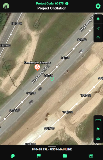
A standard centerline alignment in the OnStation App
The value of OnStation's real-time location finder is that workers on a construction job can document what they see where they are on a job. For example, a construction foreman can document the location and condition of a damaged sewer inlet grate. The foreman can share the image of the inlet, at a specific station and offset, with the DOT (department of transportation) inspector who can reference that inlet's position on the CAD file, and they can collaborate about next steps. The inspector can route a repair team to the location by sharing its position in lat/long. Years later, that inlet can be inspected and maintained by the DOT maintenance crews who are using mile markers along the freeway to understand their position. Work performed is always tied to a location. OnStation excels with linear construction projects such as roads, pipelines, canals, conduits, and rail because it supports the workers who perform work as well as the managers who must prove the work was done correctly at that location.
Now, think of a construction area or a large area asset that is not a linear construction project. Many OnStation customers successfully use the app in a defined area where construction activity takes place. Instead of a line, the work area is a polygon. Examples include solar farm installations, mining projects, private residential neighborhood construction, private roads and parking lots, park lands, rooftops, and data centers. The same requirements exist as in road construction:
Everyone must have a shared understanding of the plan design
Workers must be able to orient themselves within the job site to get where they need to be
Activity, problems, and conflicts must be documented with all pertinent metadata (who, where, when, what, how much, etc.)
Claims for payment must be supported by evidence and complete documentation
A record of what was actually constructed, the final "as-built" condition, must be retained for future reference
Defined area project workers use OnStation almost the same way as linear construction crews do; however, they may not reference any center alignment.
Why Choose Location Certainty for Defined Areas
There are three key reasons companies involved in defined area construction projects choose the OnStation platform. First, OnStation is less expensive than other location software with similar functionality, yet it still delivers enterprise-grade features to support complex reporting needs. The OnStation return on investment is quite high because these projects carry enormous financial stakes. A single hyperscale data center can run $500 million or more, and every day of delay costs hundreds of thousands of dollars in carrying costs and contract penalties. Documentation isn't just administrative here; it's financial risk management. A cheap phone app might offer a helpful hack at a low price point, and expensive vertical construction management software could provide sophisticated complexity, but OnStation lands at the sweet spot in between.
Second, it's easy for all stakeholders involved. No training is required to use OnStation; simply drop a flag, make a chat, take a picture. The project data collected can remain private and the project definition area can be described by the customer quickly and easily using simple tools. Anyone with a phone or tablet can walk the jobsite and save time.
Most importantly, OnStation solves collaboration problems out in the field. Construction crews who work in defined area projects are typically not equipped with anything beyond text, e-mail, and paper plans, and new operators come and go throughout the different project phases. OnStation lets the prime developer coordinate work across teams, phases, and different geographic areas of the project. Everyone from surveyors and estimators, to earth moving and debris clearing, to concrete and asphalt teams, can see design information, right of way, and the progress of the teams that precede or follow them. These crews prize speed-to-resolution over all.
Real World Examples
OnStation customers use the platform in a variety of ways across these project types.
Property Conglomerate: Parking Lots
A massive commercial property Conglomerate owns dozens of distribution centers and warehouses across the country. Each location includes thousands of square feet of facility and asphalt or concrete, along with many structural assets such as bollards, signs, lighting, and fencing. They use the OnStation platform to track pavement condition and to manage assets. When the Conglomerate's contracted engineering inspection firm identifies deficiencies, code violations, or damage, they're able to document those issues in OnStation and prepare a summary with estimated repair costs and timelines, without the back-and-forth of email threads and context-free photos that previously left project managers making follow-up calls just to understand where a deficiency was. The Conglomerate's facility manager can supply that OnStation data to contractors to create requests for proposals and manage post-construction punch lists. They can also create a deferred maintenance schedule to spread costs across multiple years.
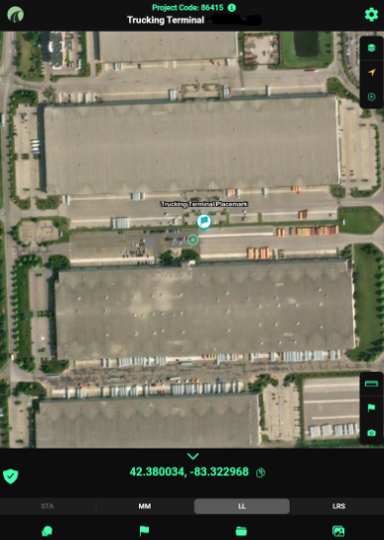
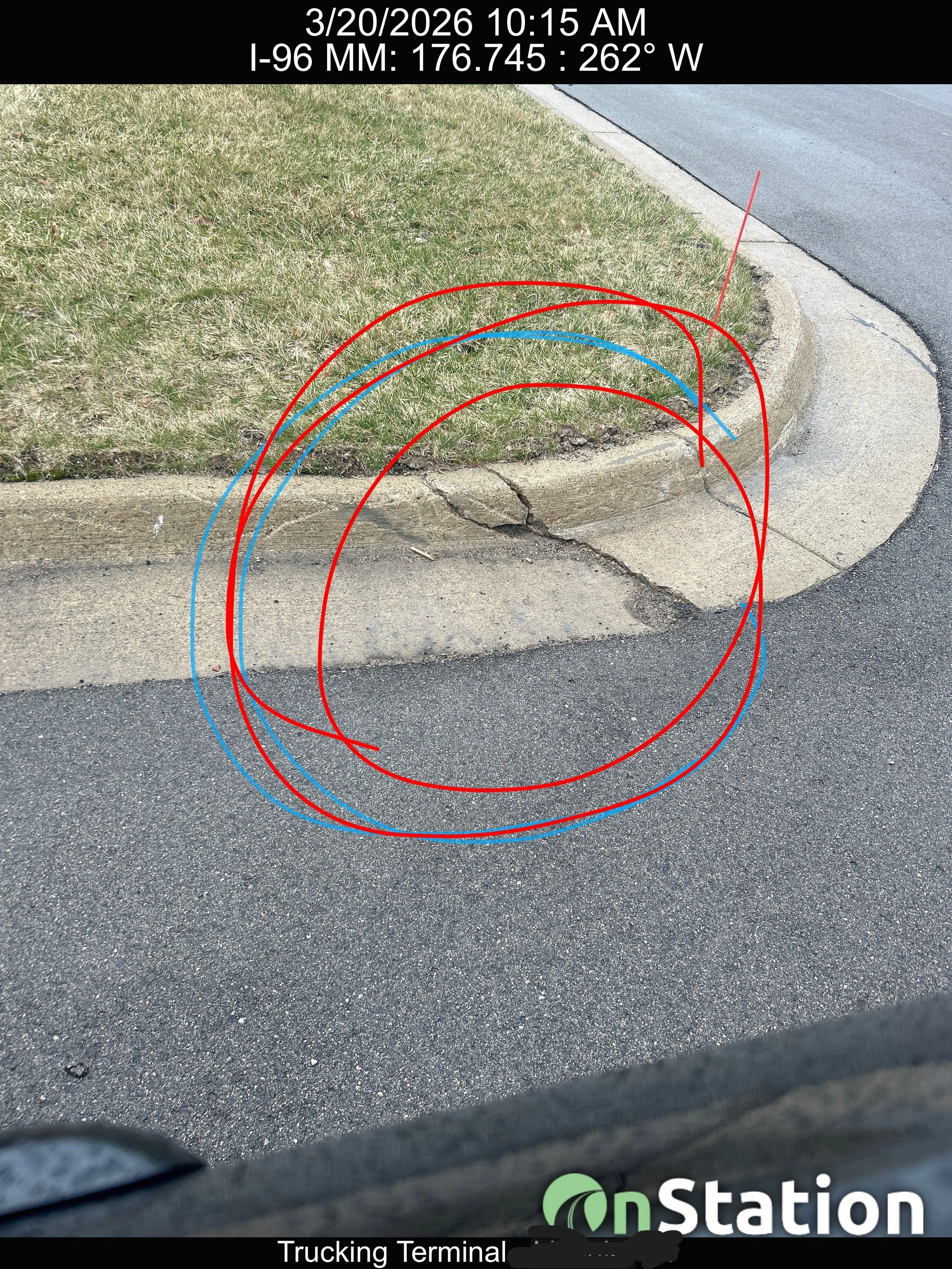
Figures: Trucking terminal private parking lot tagged with inspection findings
Manufacturer: Rooftops
Vertical construction software is a mature software market. However, it's expensive overkill if you only need to track the status of acres of roofing. A large industrial Manufacturer uses OnStation to manage maintenance of its huge corporate footprint. Acres of plant facilities feature flat, rubberized, or sealed roofing that requires regular maintenance over time. These areas are hard to access, and they can suffer storm damage that's only evident with before/after images. OnStation lets the Manufacturer document activity, repair, and current conditions for its massive physical plant operations.
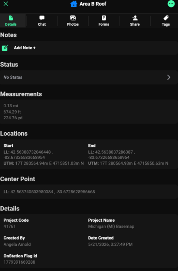
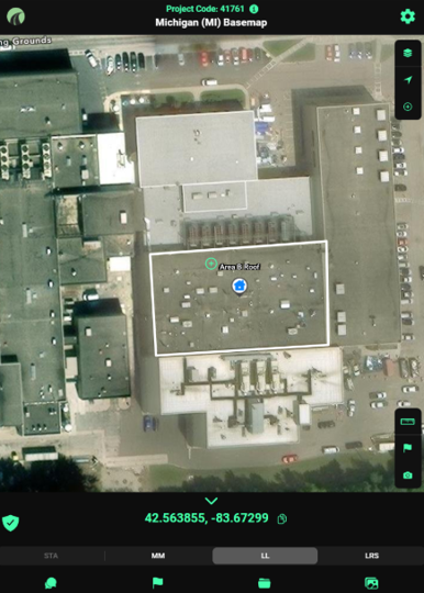
Figures: Roof flag measurement in OnStation. Users can add close-up images of rubberized surface area, HVAC equipment, hail damage, etc.
Specialty Contractor: Asset Tracking
Across a county, a roadway, or a large tract of private property, a specialty Contractor needs to capture the condition and placement of infrastructure assets such as overhead lighting, pole-mounted structures, signs, handholes, and enclosures. OnStation works with many such Contractors who install and maintain these items for DOTs, counties, municipalities, developers, and private property owners. In some cases, the defined area is a county map or city boundary. Without OnStation, the Contractor uses a paper map, email, SMS text messages, and cell phone camera gallery photos to document activity in the field. They often win work without a comprehensive map of where all the assets exist or should be placed because the owner doesn't possess that information. Thus, part of performing the work means the Contractor must create their own mapping system to route teams and organize labor. With OnStation, it takes only moments to define the project area, add team members, and start dropping flags.
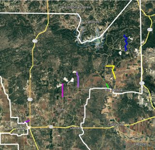
OnStation view of county (white project boundaries) with colored line areas where assets are located
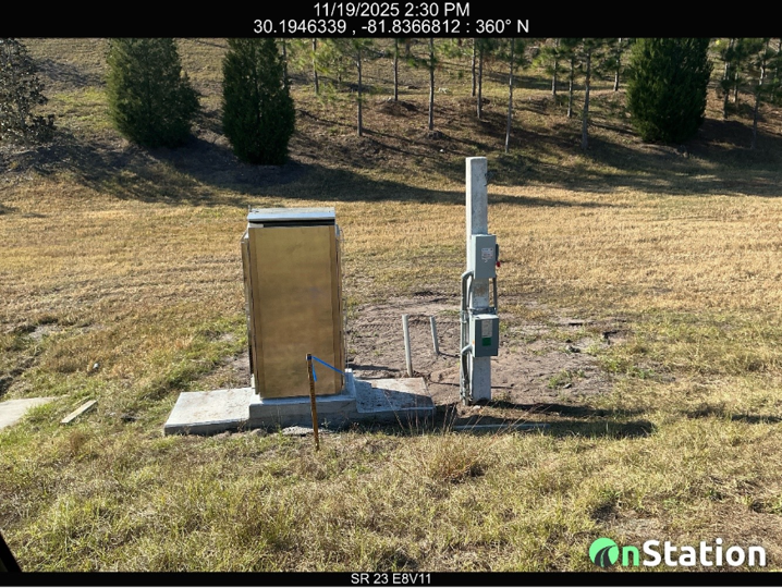
Cabinet inspection image with location, timestamp, date
Conclusion
Whether the job is a linear road project or a defined area, the challenges are the same: know where you are, document what you did, and prove it later. OnStation delivers that location certainty and defensible record across parking lots, rooftops, solar farms, data centers, and any other defined area where the work happens on the ground.