
Digital Stationing Comparison:
OnStation vs. HaulHub/EDOT
What does live, field-ready stationing look like?
How does an established platform compare to newer tools?
How accurate are these systems?
How available is digital stationing?
What’s the
main difference?
OnStation’s digital stationing is built for all project activity and users while HaulHub/EDOT’s is primarily designed around material ticketing.
Digital Stationing Comparison:
OnStation vs. HaulHub/EDOT
Before diving into digital stationing, it helps to understand what stationing is and how it’s done today. Stationing is the system crews use to mark every 100 feet along a roadway or project. It serves as a common location language, telling everyone exactly where work should happen, like a set of precise mile markers for the job.
Most teams still rely on old-school methods to track those points, such as hammering in wooden stakes, spray-painting barriers, or marking pavement so crews know where each station falls. While these methods work, markers can easily be covered up, moved, or misread, slowing communication and increasing the risk of mistakes.
Digital stationing has quickly become an essential tool for modern heavy highway and civil construction teams. It connects field data to exact project locations, improves communication, and streamlines documentation. While several platforms now offer digital stationing, their approach to it, and who they build it for, can be very different.
OnStation has been in the digital stationing business since 2014, giving it nearly a decade to refine its approach and become a recognized leader in the industry. Over that time, the platform has expanded beyond just stationing to include design overlays, documentation tools, and even safety integrations through Active Worksite™.
Intended Users
Digital stationing platforms can vary in who they are built to serve.
OnStation is structured as a shared platform for the broader project ecosystem, including inspectors, contractors, engineers, and anyone else who touches the jobsite. This approach allows multiple roles on a project to use the same reference point, tying their data and documentation directly to location.
HaulHub/EDOT focuses on material deliveries and workflows. Its alignment with DOT inspection and ticketing processes makes it well-suited for those use cases. However, it may not cover the same breadth of field documentation or collaboration needs outside of inspection.
Stationing Type
Digital stationing tools differ in how they provide location references during a project.
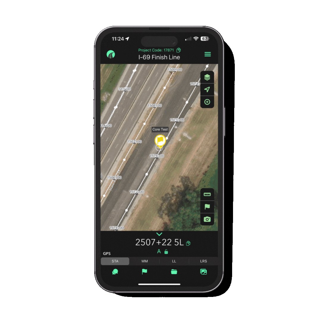
OnStation uses a live, continuous approach. The platform tells the user their current position, without them having to rely on stakes/lathe. It helps guide the worker to where they need to be to perform work. A user’s field position along the alignment is automatically detected and auto-alignment is applied, which reduces the need for manual adjustments when moving across the project.
HaulHub/EDOT provides a visual representation of the alignment, generating station and offset values when the user places a point. This method requires the user to manually select and align locations, creating a more step-by-step process for documenting the position. This means that the worker still needs to rely on GPS equipment, or survey lathe to know where they are. Calculating a station/offset after the information has been collected doesn't help tell the worker where they need to go first in order to collect that information.
Safety
OnStation elevates the safety standard industry-wide. Active Worksite™ connects your project directly to the traveling public, automatically notifying drivers when workers are present on jobsites through their everyday navigation system. Active Worksite™ connects your project directly to the traveling public. When crews are active on a jobsite, drivers are automatically notified through their everyday navigation system.
Motorists receive real-time alerts about active construction zones with workers present.
Drivers can make smarter, safer decisions to slow down, reroute, or plan ahead.
Agencies and contractors can demonstrate a proactive safety commitment, reducing risk for both crews and the public.
Projects can incorporate Active Worksite™ directly into MOT plans, ensuring traveler communication is part of the official safety strategy, not an afterthought.
This capability is unique to OnStation. It goes far beyond “digital stationing just for the crews” by turning location awareness into a safety communication tool that protects road workers and informs the traveling public.
➡️ Active Worksite™
➡️ Active Worksite™ Press Release
HaulHub/EDOT features a Work Zones function that is more integrated with its e-ticketing system. Agencies can place pins to define zones, “arm” or “disarm” them, and link them to ticket activity, often related to truck, paver, excavator, and mill movement.
This makes the system useful for tracking active zones in relation to haul operations.
The focus is on vehicle and ticket-based data, rather than direct, real-time communication with the traveling public or field-level safety for crews.
Data Collection & Project Documentation
How platforms manage field data collection can differ based on their focus and ownership of the system.
OnStation allows free-form and structured data entry linked directly to a station location. Users can record a variety of project details such as property conditions, punch list items, traffic incidents, or inspection notes, and each entry can be exported for project closeout, reporting, or sharing with stakeholders. Since OnStation licenses are sold to contractors, subcontractors, CEI firms, and DOTs, each organization retains ownership of its records and controls what to share. This method ensures teams feel secure about their documentation while still enabling collaboration when necessary.
HaulHub/EDOT also links data to reference locations, but its focus is on material tickets and tracking contract items, aligning closely with agency workflows. The platform is licensed to DOTs, with contractors given free access through the agency’s system. While this allows inspectors to manage their records centrally, it also means contractor data is stored within an agency-controlled environment, which may limit how much control project partners believe they have over their documentation.
Design Layers & Map Functionality
Access to project visuals can look different across digital stationing platforms.
OnStation allows crews to view design layers and PDF plan overlays directly in the field. This gives field staff access to the same project visuals as the design office, helping maintain consistency and reducing potential misunderstandings between teams.
HaulHub/EDOT provides map functionality through aerial or drone imagery sources. While these layers are helpful for general visual context, they do not include detailed project-specific design files or plan sheets.
Setup & Support
Different platforms offer different approaches to implementation.
OnStation provides a full-service model supported by its proprietary automation tool, which processes large volumes of project files efficiently and accurately. The OnStation engineering team then prepares alignments, applies coordinate systems, and completes setup, reducing the technical burden on field staff and ensuring crews can begin using the platform without extra configuration. In addition, OnStation offers on-site training and other support services to help teams maximize the platform in the field. This combination of automation and expert support differentiates OnStation from other systems that rely solely on raw file uploads or third-party mapping tools.
HaulHub/EDOT takes a self-service approach. Users upload XML or DGN files, enter location points, select alignments, and apply coordinate systems themselves. This can give teams more direct control over the setup process but also places responsibility for accuracy and configuration on the end user.
File Support & Compatibility
File compatibility is another area where platforms can differ.
OnStation supports multiple file types, including DGNs, DWGs, XMLs, KMLs, ALGs, and PDFs, and prepares them during setup so they are ready for use in the field. This helps ensure alignments and design information are properly configured before crews begin work.
HaulHub/EDOT supports a limited file set. Users also apply the coordinate system themselves, which provides flexibility but may require additional technical knowledge to avoid errors during setup.
Integrations
Both platforms integrate with external systems, but they focus on different needs.
OnStation integrates with Trimble, TransTech Systems, FleetWatcher, HCSS HeavyJob, and AASHTOWare Project upon request to create a connected jobsite for contractors and project teams.
HaulHub/EDOT integrates with AASHTOWare Project, contractor ticketing systems (FleetWatcher, Command Alkon), and consolidates the data into an agency-owned portal focused on inspection and material movement.
Pricing Transparency
How pricing is communicated can affect how organizations plan and budget for technology.
OnStation publishes its pricing openly. Licenses range from $46–$91 per user, per month, depending on license type (Locate, Capture, or Data). Add-ons like Active Worksite™ and integrations are also priced clearly per year or per project. This consistency makes it easier for contractors and agencies to forecast costs and manage budgets.
HaulHub/EDOT does not currently publish pricing information outside of their e-ticketing offering available in the AASHTOWare Project catalog. Without publicly available details, organizations need to engage directly with the vendor to understand costs and the scope of the offering, which can make comparison and long-term planning more challenging.
Bottom Line
Choosing the right digital stationing platform really depends on your team’s needs.
OnStation is built for full-project use, giving inspectors, contractors, engineers, and field crews live digital stationing, design overlays, flexible data capture, and hands-on support.
Shaped by years of real-world use and field team feedback, OnStation continuously releases product updates that enhance functionality and solve every day jobsite challenges. This history of iteration shows that OnStation isn’t just a tool, but a living solution designed to keep pace with the evolving needs of heavy highway and civil construction.
For teams in the field, this means reliability and confidence, knowing the technology is proven, trusted, and continually refined to meet the demands of today’s jobs.
HaulHub/EDOT is primarily designed around material ticketing, with workflows that align closely with DOT ticketing and reporting requirements. For agencies or teams whose primary need is managing electronic tickets and ensuring compliance, this focus may make the platform a suitable fit.
Currently, the product remains relatively new and has seen limited use in the field compared to longer-standing tools. Information available online points mostly to pilot programs and early-stage adoption. Because of this, its broader capabilities for full-project use, such as daily crew workflows, station-based documentation, or integrated field communication, are not yet well defined.
As adoption grows and more case studies are shared publicly, along with additional details becoming available, the overview will be updated to provide a balanced, fact-based comparison of how EDOT develops alongside other solutions in the industry.
At the end of the day, what matters most is that you select the platform that helps your people work safer, faster, and more connected. We hope this information helps you choose the stationing tool that is right for you.
STA: 1786+45 14R
=
MM: 461.991
=
LL: 30.380179,-95.067204
=
LRS: 461.458 2L
=
STA: 1786+45 14R = MM: 461.991 = LL: 30.380179,-95.067204 = LRS: 461.458 2L =
From the Field

FREE Stationing Training
Our stationing experts created these training videos to help individuals in the industry learn about the most important aspect of a job… Location!
Stationing is the project locationing system that allows individuals to budget, design, and construct roadway projects. The following lessons will cover the different types of stationing and why they are important.